Geographic Area
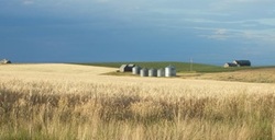
The Teton Soil Conservation District (SCD) has the same physical boundaries as Teton County, Idaho. It is located in eastern Idaho and borders the State of Wyoming to the east and is known as the Teton Valley. It is ringed on three sides by mountain ranges. The spectacular Grand Teton Mountain Range dominates the valley with magnificent mountain vistas. The foothills of these mountains form the eastern boundary of the district. To the south, the Snake River range marks the divide between the Snake River drainage and the Teton River drainage. To the west the Bighole mountain range forms the western boundary of Teton SCD. The Teton River, a sportsman’s paradise, meanders through this high alpine valley from the south to the north, draining the entire area. Numerous tributaries flow into the Teton River from various watersheds. The valley elevations range from 5,800 to 7,000 feet. The high elevation creates a rigorous climate of long, cold winters and moderately warm summers with frost recorded nearly every month of the year. The valley is approximately 20 miles long and about 12 miles wide at the widest point and consists of approximately 459 square miles (294,012 acres). Teton County is the second smallest county in Idaho. Most of the County is in private holdings (65%), with Federal or State managed lands constituting approximately 34% of the County. The remaining 1% of land base consists of waterways. Total privately owned acres are approximately 191,275. Four main arterial highways provide access to Teton Valley. The topography ranges from the high elevation (6,000 ft. average) Teton Basin that drains the Teton River and its tributaries, to the Big Hole Mountains in the southwest portion of the County, where peaks reach 9,000 ft. Counties that border Teton County include Bonneville, Madison, and Fremont Counties, as well as the State of Wyoming’s own Teton County. Thirty-one different soil series have been identified within the Teton SCD.
The Teton Soil Conservation District (SCD) has the same physical boundaries as Teton County, Idaho. It is located in eastern Idaho and borders the State of Wyoming to the east and is known as the Teton Valley. It is ringed on three sides by mountain ranges. The spectacular Grand Teton Mountain Range dominates the valley with magnificent mountain vistas. The foothills of these mountains form the eastern boundary of the district. To the south, the Snake River range marks the divide between the Snake River drainage and the Teton River drainage. To the west the Bighole mountain range forms the western boundary of Teton SCD. The Teton River, a sportsman’s paradise, meanders through this high alpine valley from the south to the north, draining the entire area. Numerous tributaries flow into the Teton River from various watersheds. The valley elevations range from 5,800 to 7,000 feet. The high elevation creates a rigorous climate of long, cold winters and moderately warm summers with frost recorded nearly every month of the year. The valley is approximately 20 miles long and about 12 miles wide at the widest point and consists of approximately 459 square miles (294,012 acres). Teton County is the second smallest county in Idaho. Most of the County is in private holdings (65%), with Federal or State managed lands constituting approximately 34% of the County. The remaining 1% of land base consists of waterways. Total privately owned acres are approximately 191,275. Four main arterial highways provide access to Teton Valley. The topography ranges from the high elevation (6,000 ft. average) Teton Basin that drains the Teton River and its tributaries, to the Big Hole Mountains in the southwest portion of the County, where peaks reach 9,000 ft. Counties that border Teton County include Bonneville, Madison, and Fremont Counties, as well as the State of Wyoming’s own Teton County. Thirty-one different soil series have been identified within the Teton SCD.
The Teton Soil and Water Conservation District was officially organized on February 10, 1950 by a group of farmers in the interest of making available technical, financial and educational resources, whatever their source, and focus or coordinate them so that they meet the needs of the local land managers in conserving soil, water and related natural and other resources.
The present day board consists of:
J. Lynn Bagley, Board Chairman
Garl Drake, Vice-Chairman
Clyde Ricks, Secretary-Treasurer
Stacy Lerwill, Supervisor
Harley Hill, Supervisor
Glen Nelson, Associate
J. Lynn Bagley, Board Chairman
Garl Drake, Vice-Chairman
Clyde Ricks, Secretary-Treasurer
Stacy Lerwill, Supervisor
Harley Hill, Supervisor
Glen Nelson, Associate
Our Mission Statement:
Teton Soil Conservation District's mission is to work with willing landowners in a non-regulatory manner to reduce erosion, protect water quality, improve air quality and fish and wildlife habitat, provide assistance to landowners and conduct an active information and education program. Landowners receive technical assistance through the Natural Resources Conservation Service.
Teton Soil Conservation District's mission is to work with willing landowners in a non-regulatory manner to reduce erosion, protect water quality, improve air quality and fish and wildlife habitat, provide assistance to landowners and conduct an active information and education program. Landowners receive technical assistance through the Natural Resources Conservation Service.
